
Campo dei Fiori Trail, 2024. Info and routes.
Campo dei Fiori Trail - Gavirate, Italy.
Sunday, March 10, 2024
Disclaimer - "Campo dei Fiori Trail" is NOT organized by goandrace.com. Learn more here.
Information about Campo dei Fiori Trail, 2024 ed.
Running event name: Campo dei Fiori Trail
Date and Time: Sunday, March 10, 2024
City: Gavirate
Address: via Lido
c/o:
Region: Lombardia - Province: Varese - County: Gavirate
Country: Italy
Latitude and longitude: 45.838045 8.711824
About the event:
Other notes:
Virtual Race? No
Trail? Yes
Cross country event? No
Multi-stage event? No
Initiatives for children and families: No information
How to apply and entry fee:
Award Description:
Dressing rooms:
Aid stations:
Website: campodeifioritrail.it
E-mail: info@CampodeiFioriTrail.it
: www.facebook.com/trailcampodeifiori
: www.instagram.com/campodeifioritrail
Flier: Click here
Final ranking: Not available
Campo dei Fiori Trail route, 2024 ed.
| # | Length | Race type | Route and gpx file | Terrain type | |
|---|---|---|---|---|---|
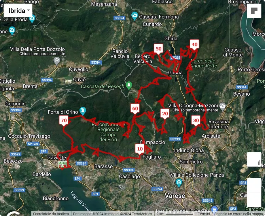
| Race 1 | 75.5 km (46.9 mi) |
Ultramarathon | 75.5 km course map 3D video animation of the 75.5 km path |
Not available | |
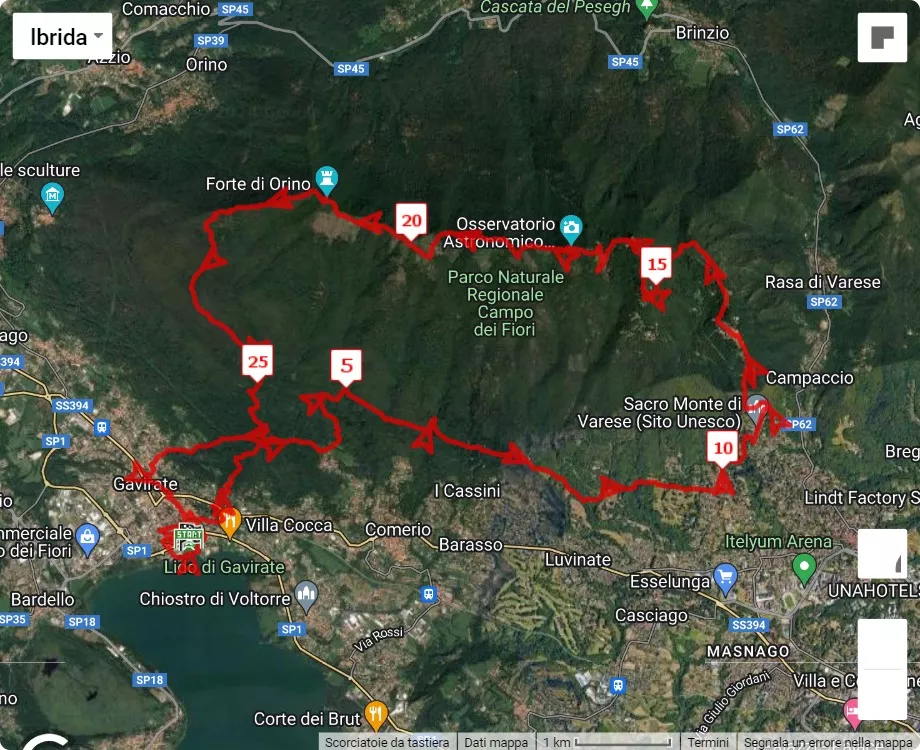
| Discover the race route of the Campo dei Fiori Trail, 75.5 km, by clicking on the link or on the map below. Altimetry information. Download gpx file. | |||||
|
|||||
|
3D video animation of the 75.5 km path | |||||
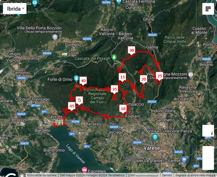
| Race 2 | 49 km (30.5 mi) |
Ultramarathon | 49 km course map 3D video animation of the 49 km path |
Not available | |
| Discover the race route of the Campo dei Fiori Trail, 49 km, by clicking on the link or on the map below. Altimetry information. Download gpx file. | |||||
|
|||||
|
3D video animation of the 49 km path | |||||
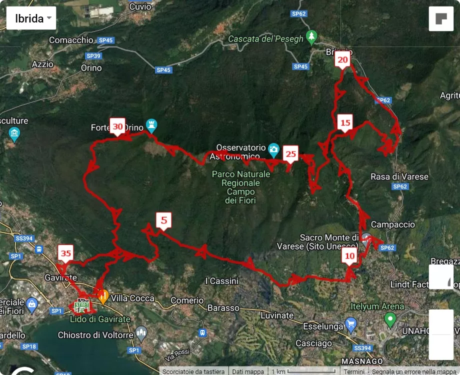
| Race 3 | 38 km (23.6 mi) |
Competitive race | 38 km course map 3D video animation of the 38 km path |
Not available | |
| Discover the race route of the Campo dei Fiori Trail, 38 km, by clicking on the link or on the map below. Altimetry information. Download gpx file. | |||||
|
|||||
|
3D video animation of the 38 km path | |||||
| Race 4 | 28 km (17.4 mi) |
Competitive race | 28 km course map 3D video animation of the 28 km path |
Not available | |
| Discover the race route of the Campo dei Fiori Trail, 28 km, by clicking on the link or on the map below. Altimetry information. Download gpx file. | |||||
|
|||||
Gavirate weather forecast
To see the weather forecast of the Lombardia region by firenzemeteo.it click on the link or on any of the following maps.
For Gavirate weather forecast click on the link.
Other nearby races
Events on the same day at a distance of less than 50 km (31 from Gavirate as the crow flies are reported here.
| Country | Region or State | City | Event name | Info |
| Italy | Piemonte-NO | Fontaneto d'Agogna | Camminata delle Baragge | Link |
| Italy | Lombardia-MI | Magnago | Magnago Roggie Run | Link |
| Italy | Lombardia-CO | Erba | 3° Trofeo Lanfritto Maggioni - 47° Trofeo Maria Agnese Ciceri | Link |
Disclaimer - "Campo dei Fiori Trail" is NOT organized by goandrace.com.
The event information on this website is collected from public sources and believed to be reliable at the time of publication.
However, we are not the organizers of these events and cannot guarantee the accuracy, completeness, or currency of the information provided.
The images on goandrace.com are with free license if taken on
pexels.com or from
unsplash.com or with Creative Commons BY or BY-SA
license if taken on wikipedia.org.
Learn more here.
Message for running race organizers
Are you part of the organizing committee of the running event
named Campo dei Fiori Trail
and would you like to be the one to manage the information, adding more details?
Register (if you have not already done) and log-in to see here the link to forward the request to Go&Race administrators.
Registration on Go&Race and event management are completely free. There are no paid services on Go&Race.